Browse the Collection
3 resources
3 items
Spatial coverage
North America
Type
Still image
-
 Still image
Die eigentliche warhafftige gestalt der Erden und des [...]
CopyrightNO COPYRIGHT - UNITED STATES Free
Free
to useA map of the world including Europe, Africa ("Der schwarzen Moren Land"), Asia (Major), America ("Die Newe Welt"), and India Meridionalis (a so called "phantom" peninsula that was often depicted in Medieval and Rennaissance maps). A number of monstrous sea creatures are depicted in the various oceans and seas. -
 Still image
Die ganze Welt in einem [K]leberblat Welches [...] meines lieben Vaterlandes [W]apen
CopyrightNO COPYRIGHT - UNITED STATES
Free
to useA map of the world including Europe, Africa, and Asia as three leaf or petal shaped continents with America ("Die Newe Welt") draw in the bottom left corner. A ship and numerous sea creatures are depicted in the oceans. -
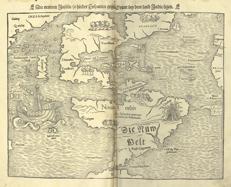 Still image
Die neuwen Inseln - so hinder Hispanien gegen Orient bey dem land Indic ligen.
CopyrightNO COPYRIGHT - UNITED STATES
Free
to useA map of the western hemisphere, identified as the New World, and the western coast of Asia. A spanish style galleon ship is depicted sailing in the Pacific ocean, and a rough shelter built of sticks featureing a dismembered leg is depicted in the general region of Brazil with the label, "Canibali".