Search
-
 Still image
Bridegroom and friends going to fetch the bride, Ramallah
Hurlbut, Jesse Lyman, 1843-1930CopyrightNO COPYRIGHT - UNITED STATES Free
Free
to useA procession of a bridesgroom and his friends along a street in the city of Ramallah to collect the bride. -
 Still image
Little folks studying at the village school in Samuel's home town, Ramah
Hurlbut, Jesse Lyman, 1843-1930CopyrightNO COPYRIGHT - UNITED STATES
Free
to useA class of children learning Arabic in the town of Bayt Rīmā. -
 Still image
From Ramah, traditional home of Samuel, N. E. toward Gilead, Palestine
Hurlbut, Jesse Lyman, 1843-1930CopyrightNO COPYRIGHT - UNITED STATES
Free
to useA view of the town of Bayt Rīmā which may be the biblical town of Ramah, where Samuel was born. -
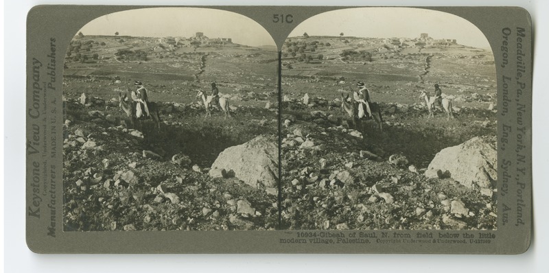 Still image
Gibeah of Saul, N. from field below the little modern village
Hurlbut, Jesse Lyman, 1843-1930CopyrightNO COPYRIGHT - UNITED STATES
Free
to useA view of the modern town which stands near the ancient site of Gibeah, the home of Saul, the first king of Israel. -
 Still image
Anathoth, Jeremiah's home town — N.E. toward Jordan and Gilead, Palestine
Hurlbut, Jesse Lyman, 1843-1930CopyrightNO COPYRIGHT - UNITED STATES
Free
to useA view of the town of Anathoth (ʻAnātā) from the foot of Mount Scopus. -
 Still image
Scene of Jonathan's victory at Michmash, Wady es Suweinit, Palestine
Hurlbut, Jesse Lyman, 1843-1930CopyrightNO COPYRIGHT - UNITED STATES
Free
to useA view of the valley in which Jonathan won his victory at Michmash. -
 Still image
Old road from Jericho to Ai (west), among the hills of Benjamin, Palestine
Hurlbut, Jesse Lyman, 1843-1930CopyrightNO COPYRIGHT - UNITED STATES
Free
to useThe road leding from the ancient city of Jericho to the biblical city of Ai. -
 Still image
From Ramoth Gilead : N. W. over Jordan valley toward distant Carmel, Palestine
Hurlbut, Jesse Lyman, 1843-1930CopyrightNO COPYRIGHT - UNITED STATES
Free
to useA view from Al-Salt (Salṭ) across the Jordan River Valley with Mount Carmel barely visible in the background. -
 Still image
Jerash (Gerasa) in eastern Gilead; looking N. over Roman ruins, Syria
Hurlbut, Jesse Lyman, 1843-1930CopyrightNO COPYRIGHT - UNITED STATES
Free
to useA view of the ancient city of Gerasa near modern Jerash in Jordan showing the ruined remnants of a Greco-Roman city. -
 Still image
"Roses of Sharon", on the Plain of Sharon
Hurlbut, Jesse Lyman, 1843-1930CopyrightNO COPYRIGHT - UNITED STATES
Free
to useView of the Plains of Sharon, showing a patch of the plant, Rose of Sharon. -
 Still image
Relief map of Palestine by the Palestine Ex. Soc.—vertical scale 3 1/2 times greater than horizontal
Hurlbut, Jesse Lyman, 1843-1930CopyrightNO COPYRIGHT - UNITED STATES
Free
to useView of a relief map prepared by the Palestine Exploration Society depicting the topography of Palestine and identifying various notable locations. -
 Still image
A caravan of camels in the narrow road approaching Jaffa
Hurlbut, Jesse Lyman, 1843-1930CopyrightNO COPYRIGHT - UNITED STATES
Free
to useA caravan of camels and traders on the road into Jaffa. -
 Still image
The house of Simon the Tanner, Jaffa
Hurlbut, Jesse Lyman, 1843-1930CopyrightNO COPYRIGHT - UNITED STATES
Free
to useView of the house of Simon the Tanner in Jaffa, where Peter stayed during his mission. The story of this is told in the Acts of the Apostles. -
 Still image
The Bazaar of Jaffa on a market day
Hurlbut, Jesse Lyman, 1843-1930CopyrightNO COPYRIGHT - UNITED STATES
Free
to useView of the Jaffa bazaar from above. -
 Still image
Jaffa, the Joppa of the Bible times
Hurlbut, Jesse Lyman, 1843-1930CopyrightNO COPYRIGHT - UNITED STATES
Free
to useView of Jaffa (Joppa, in the Bible) from a boat in the Mediterranean. -
 Still image
Nazareth (En-Nazira)
Williams Engraving Co., N.Y.CopyrightNO COPYRIGHT - UNITED STATES
Free
to useA map showing the corresponding locations where stereoscopic images were taken of Nazareth and surrounding areas. -
 Still image
Section of Galilee
Bormay & Co. Engravers, N.Y.CopyrightNO COPYRIGHT - UNITED STATES
Free
to useA map showing the corresponding locations where stereoscopic images were taken of Galilee. -
 Still image
Samaria (Sebastie)
Bormay & Co. Engravers, N.Y.CopyrightNO COPYRIGHT - UNITED STATES
Free
to useA map showing the corresponding locations where stereoscopic images were taken of Samaria Region. -
 Still image
The Vale of Shechem (Nablus)
Bormay & Co. Engravers, N.Y.CopyrightNO COPYRIGHT - UNITED STATES
Free
to useA map showing the corresponding locations where stereoscopic images were taken of Nablus (Shechem) and the surrounding areas. -
 Still image
Jericho and Surroundings
Bormay & Co. Engravers, N.Y.CopyrightNO COPYRIGHT - UNITED STATES
Free
to useA map showing the corresponding locations where stereoscopic images were taken of Jericho and the surrounding areas. -
 Still image
Bethlehem and Vicinity
CopyrightNO COPYRIGHT - UNITED STATES
Free
to useA map showing the corresponding locations where stereoscopic images were taken of Bethlehem and the surrounding areas.
Page 234 of 237